Overview
Signatures of Evaporation of Artificial Snow in Alpine Lower Troposphere (SEASALT) is a students' research project within the Education & Training framework of the EUropean Fleet for Airborne Research (EUFAR).
 Conducted research is aimed at:
- obtaining a proof and scale-estimation of the process of advection of the water vapour introduced into the atmosphere during man-made snow production which may have a significant impact on the Alpine water-budget
- checking for various local microphysical interaction between the atmosphere and the artificially introduced man-made snow (aerosol concentrations e.g.)
- contributing to a general air-quality comparison between the highly-urbanised ski-resorts and tourist-free valleys
The project is led by Sylwester Arabas
(Institute of Geophysics, University of Warsaw, Poland).
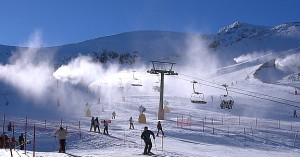
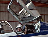
The field measurement campaign, which was carried out in the Enns river valley in Austria in February/March 2008, was funded by EUFAR as a Transnational Access project. The airborne measurements were carried out onboard the FZK-ENDURO ultralight trike operated by Dr. Wolfgang Junkermann (Forschungszentrum Karlsruhe, Germany)
Field measurements
The field measurements campaign, focused on the airborne measurements on board the FZK-ENDURO ultralight trike, was carried out in the Enns river valley in Austria in the end of February, beginning of March 2008.
The FZK-ENDURO is equipped with a variety of instruments including:
(hemispherical broadband UV irradiance in the 300 to 700 nm range)
(2 Pyranometers measuring up- and downward hemispherical broadband solar irradiance)
(hemispherical broadband UV irrandiance)
(ozone mixing ratio by means of UV-Absorption measurement with 4 sec. time resolution)
(thermo-electric chilled mirror hygrometer )
(formaldehyde concentration with 90 sec. response time)
(CO2 and H2O concentration by means of IR absorption measurements)
(particle concentration in the size range from 10 nm to 3 um with 1 sec. time resolution)
(particle size distribution in the range from 0.3 to 20 um)
(cloud droplets size distribution in the range of 5 - 47 um with 1Hz time resolution)
(absorption coefficient at 7 wavelenghts from 350 to 950 nm, time resolution 2 min.)
(backscatter and total scatter coefficients at 3 wavelengths from 450 to 700 nm)
(airspeed, aircraft orientation, instrument mounted on the nose-boom, operating in 20Hz time resolution)
(aircraft orientation with 80Hz time resolution)
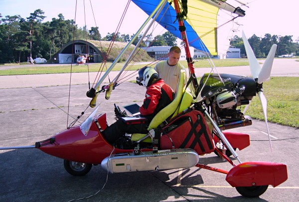
photo: K. Bednarek, IGFUW
The team
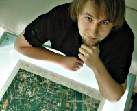
 Sylwester Arabas (University of Warsaw, Poland) Sylwester Arabas (University of Warsaw, Poland)MSc student in the University of Warsaw, Faculty of Physics, Institute of Geophysics. Current research concentrated on analyses of cloud microphysical properties based on data from airborne measurements. |
 Lisa Haga (University of Helsinki, Finland) Lisa Haga (University of Helsinki, Finland)MSc student in the University of Helsinki, Faculty of Science, Department of Physical Sciences. Studies concentrated on meteorology and geophysics. |
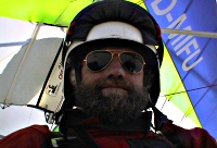 Wolfgang Junkermann (Forschungszentrum Karlsruhe, Germany) Wolfgang Junkermann (Forschungszentrum Karlsruhe, Germany)Senior scientist in the Institut fur Meteorologie und Klimaforschung, pilot and maintainer of the FZK-ENDURO. Research concentrated on air chemistry, micrometeorology, aerosol physics and atmospheric shortwave radiation. |
 Bartosz Kulawik (Jagiellonian University, Poland) Bartosz Kulawik (Jagiellonian University, Poland)PhD student in the Jagiellonian University in Cracow within the Faculty of Geography Information Science (GIS), Cartography and Remote Sensing. Research work mostly concentrated on glacier fluctuation and application of GIS and Remote Sensing methods and data. |
 Pierre Paccard (University of Savoy, France) Pierre Paccard (University of Savoy, France)PhD student in the University of Savoy, Edytem Department. Working on synthesis of effects of artificial snow on the water cycle in the French Alps. |
Related materials
Quick-look data
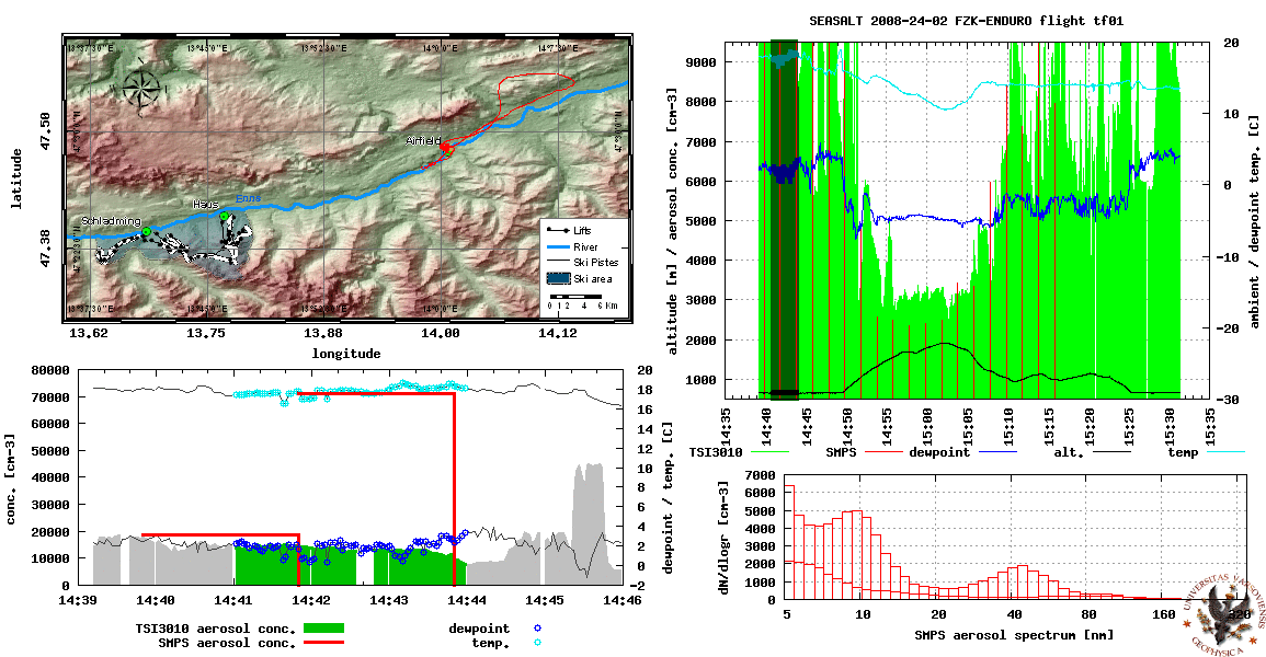
- Flight summary animations
- tf01 / 2008-02-24 [GIF, 4.0 MiB] [PDF, 4.3 MiB]
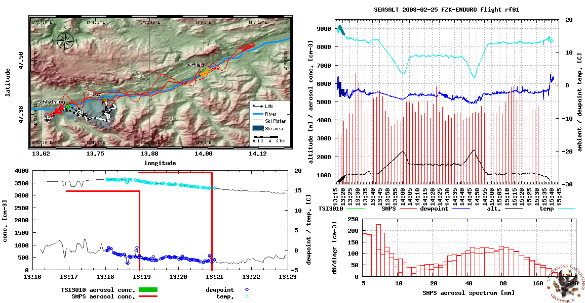
- rf01 / 2008-02-25 [GIF, 11 MiB] [PDF, 12 MiB]
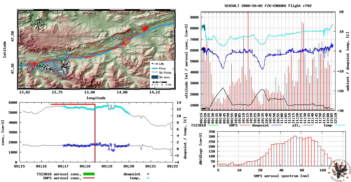
- rf02 / 2008-02-26 [GIF, 13 MiB] [PDF, 14 MiB]
- rf03 / 2008-03-06 [GIF, 11 MiB] [PDF, 12 MiB]
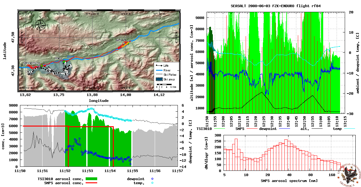
- rf04 / 2008-03-06 [GIF, 6.4 MiB] [PDF, 6.9 MiB]
- summary of ground-based measurements (meteo, radiation, fluxes)
- 2008-02-24 - 2008-03-07 [PDF, 87KiB] [PNG, 420KiB]
SEASALT documents
- EGU 2008 SEASALT poster [PPF, 39 MiB]
- Campaign Diary [PDF, 52 MiB]
- Project proposal:
- initial version [PDF, 1.5 MiB]
- EUFAR back-office version [PDF, 18 KiB]
- figure sheet for EUFAR back-office version [PDF, 1.4 MiB]
- update after assignment of the FZK-ENDURO [PDF, 16 MiB]
- Seminars:
- @IGFUW, Warsaw 2007-06-06 [slides in Polish, PDF, 20 MiB]
Photos
Picassaweb gallery with a selection of photos from the field campaign in Austria
Web links
- Affiliations
- Institute of Geophysics, University of Warsaw, Poland
- European Fleet for Airborne Research, EU
- Forschungszentrum Karlsruhe, Germany
- Field measurements region information
- SkiCircus Information @lift.at
- The Zell am See airport (mostly in German)
- The St. Johann Airport (only in German)
- Niederoblarn Airport (only in German)
- St. Johann in Tirol ski resort
- Meteorological information sources:
- Austrian Central Institute for Meteorology and Geodynamics
- Weather-related products (only in German)
- Aviation weather @austrocontroll.at / @flug-wetter.at (products only in German, registration required)
- ICMUW COAMPS model results (13km grid, 72h forecasts)
- Current meteograms for the field measurements region:
- Other subject related websites:
Press/w3 cuttings:
- Artificial Snow Harming Alpine Environment, Researchers Warn, Spiegel Online 18/04/2008
- The SEASALT project, iLEAPS website 12/2007
- Artificial snow drains mountain resources, Environmental Research Web 08/08/2007
- The slippery slope of winter sports, 06/08/2007
- Artificial snow causes real problems, Telegraph.co.uk 21/04/2007
- Artificial snow harms Alpine water system, Reuters 18/04/2007
- Snow Cannons against the Apocalypse, Spiegel Online 03/01/2007
Restricted access materials
Timeline
- 2008-07-28 SEASALT dataset v0.3 release (airborne + flux + meteo)
- 2008-07-21 SEASALT airborne dataset v0.2 release
- 2008-05-22 SEASALT airborne dataset v0.1 release
- 2008-04-24 SEASALT seminar in the University of Helsinki (LH)
- 2008-04-17 EGU 2008 SEASALT poster
- 2008-04-12 SEASALT meeting in Cracow (BK+PP+SA)
- 2008-03-20 SEASALT meeting in Helsinki (LH+SA)
- 2008-02-23 : 2008-03-08 Field measurements in Austria
- 2008-02-04 SEASALT meeting in Garmisch (WJ+SA)
- 2008-01-24 SEASALT meeting in Warsaw (BK+SA)
- 2007-12-12 Lisa, Bartosz and Pierre join the campaign
- 2007-11-26 We've got a website!
- 2007-11-20 Final acceptance by EUFAR - funds granted
- 2007-09-25 Appointment of the FZK-ENDURO by EUFAR - decision pending
- 2007-06-06 Seminar presenting the proposal in University of Warsaw
- 2007-05-31 Submission of the project proposal to EUFAR
- 2007-04-16 EGU 2007 Great Debate: We must curtail the use of artificial snow
Datasets
Please follow the links below to download SEASALT datasets. Data is provided in netCDF format (easily readable e.g. by the GNU Data Language, IDL or Matlab). Description of variables and units follow NCAR/nimbus conventions (rf - research flight, tf - test flight).- airborne measurements
- ENDURO tf01 (Feb 24th 2008)
[datafile (gzipped netcdf, 190KiB)] [header (text, 16KiB)] - ENDURO rf01 (Feb 25th 2008)
[datafile (gzipped netcdf, 330KiB)] [header (text, 35KiB)] - ENDURO rf02 (Feb 26th 2008)
[datafile (gzipped netcdf, 310KiB)] [header (text, 34KiB)] - ENDURO rf03 (Mar 6th 2008)
[datafile (gzipped netcdf, 180KiB)] [header (text, 31KiB)] - ENDURO rf04 (Mar 6th 2008)
[datafile (gzipped netcdf, 110KiB)] [header (text, 21KiB)] - ground-based meteo measurements (temperature, humidity, solar radiation, precipitation, wind)
- Niederoeblarn (IGFUW station incl. Vaisala WXT510 and Kipp & Zonen CMP-22)
[datafile (gzipped netcdf, 39KiB)] [header (text, 23KiB)] - Radstadt (ZAMG station no. 11147)
[datafile (gzipped netcdf, 25KiB)] [header (text, 28KiB)] - Groebming (ZAMG station no. 11359)
[datafile (gzipped netcdf, 26KiB)] [header (text, 28KiB)] - Ramsau (ZAMG station no. 11351)
[datafile (gzipped netcdf, 26KiB)] [header (text, 28KiB)] - ground-based flux station measurements (sensible & latent heat fluxes, momentum flux, CO2 flux)
- Niederoeblarn IMK-IFU/FZK station including CSAT3 sonic anemometer, LI-7500 gas analyzer and HMP45C temp. and humidity probe
[datafile (gzipped netcdf, 76KiB)] [header (text, 17KiB)]
Hyperlinks above lead to v0.3 dataset, for previous release change v0.3 into v0.1 or v0.2 in the url.
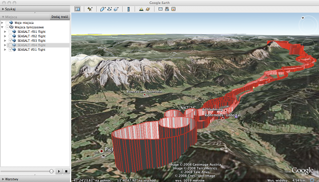
The following KML files can be used to view SEASALT flights trajectories in various geo-visualisation tools including the free Google Earth tool (see screenshot below).
- tf01 (Feb 24th 2008) 41KiB
- rf01 (Feb 25th 2008) 127KiB
- rf02 (Feb 26th 2008) 119KiB
- rf03 (Mar 6th 2008) 107KiB
- rf04 (Mar 6th 2008) 62KiB
The SEASALT Campaign Diary might be a valuable companion for data analysis as it covers a record of meteo conditions as well as some quick-look plots. Flight trajectories together with some basic atmospheric parameters are presented in Flight summery animations. (see Related materials tab)